
Cart 2 india
In2Cart
Rs. 0
0


Product Information
Specification
Brand : YellowMaps
BulletPoint : This is part of the Push-Pull Switches Product Line for Cole Hersee
BulletPoint1 : Printed on Polypropylene (plastic)
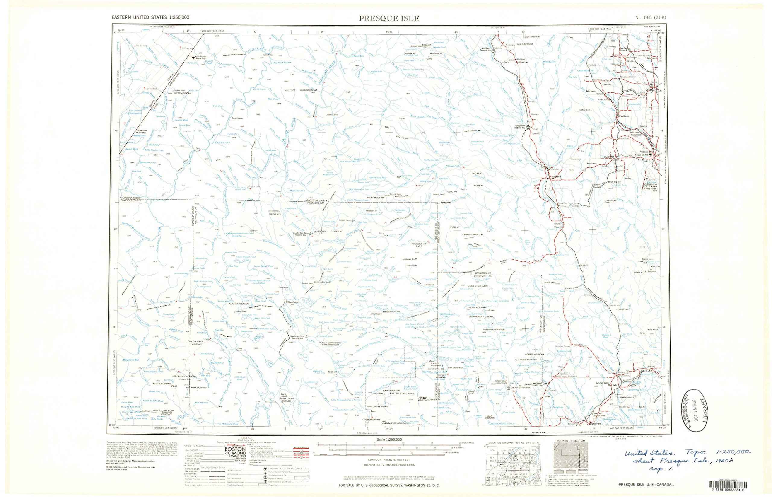
BulletPoint2 : USGS topographic map of Presque Isle, ME, at 1:250000 scale. Heavier material. Waterproof. Tear-resistant. Foldable. Perfect for the outdoors.
BulletPoint3 : Cities, towns, villages: Pine Knoll,Bugbee,Huson Landing,Hersey,Carson,Ashland,Walker Settlement,Margison,Wheelock Mill,Halls Corner,Caribou,Knowles Corner,Deadmans Corner,Bennett,Dudley,The Crossing,Presque Isle Junction,Ogren,Weeksboro,North Lyndon,Acadia,Pride,Rands,Mapleton,Griswold,McKeen Crossing,Oxbow,Spragueville,Russell Crossing,Skerry,Presque Isle,North Wade,Walker,State Road,Smyrna Center,Smyrna Mills,Barretts,Adaline,Round Mountain,Dyer Brook,Moosehorn Crossing,McNally,Shorey
BulletPoint4 : Islands: Donnelly Island,Gero Island,Stratton Island,Louse Island,Rosies Rock,Blueberry Island,Zella Island,Big Island
BulletPoint5 : Parks and forests: Baxter State Park,Arnold Brook Lake Recreation Area,Veterans Memorial Park,Mantle Lake Park,Bicentennial Park,Aroostook State Park,Allagash State Wilderness Waterway,Peace Park,Thomas Park
Color : Polypropylene
ConnectorType : Quick Connect
ExternallyAssignedProductIdentifier1 : 632850313001
ExternallyAssignedProductIdentifier2 : 0632850313001
ExternallyAssignedProductIdentifier3 : 00632850313001
Hazmat1 : LITHIUM ION BATTERIES PACKED WITH EQUIPMENT
Hazmat2 : UN3481
Hazmat3 : II
InternationalProtectionRating : IP00
ItemName : YellowMaps Presque Isle ME topo map, 1:250000 Scale, 1 X 2 Degree, Historical, 1960, Updated 1960, 22.2 x 34.5 in - Polypropylene
ItemPackageDimensions_Height : 1.5 inches
ItemPackageDimensions_Length : 4 inches
ItemPackageDimensions_Width : 1.8 inches
ItemPackageQuantity : 1
ItemTypeKeyword : outdoor-recreation-topographic-maps
Manufacturer : USGS
MapType1 : Road
MapType2 : Topographic
MapType3 : Recreation
MapType4 : Historical
ModelNumber : 50002-BX
MountingType : Tabletop Mount
NumberOfItems : 1
OperationMode : ON-OFF
PartNumber : USGS-5684975-POLY
PowerSourceType : Battery Powered
ProductDescription : Printed on Polypropylene
ProductSiteLaunchDate : 2018-12-03T12:30:29.439Z
SpecificationMet : IP64
SupplierDeclaredDgHzRegulation : not_applicable
UnitCount : 1
UnspscCode : 55101500
WaterResistanceLevel : waterproof