
Cart 2 india
In2Cart
Rs. 0
0


Product Information
Specification
Binding : map
Brand : MapTools
BulletPoint1 : For use with UTM, MGRS, USNG or other metric based coordinate systems.
BulletPoint2 : For use on maps with scales of: 1:500 1:10000 1:15000
BulletPoint3 : Travel Bug
BulletPoint4 : National Park
BulletPoint5 : Valleys: Low elevation topographic features such as flatlands, river valleys, and canyons.
Color : Multicolor
ExternallyAssignedProductIdentifier1 : 0824249150179
ExternallyAssignedProductIdentifier2 : 824249150179
Format : folded_map
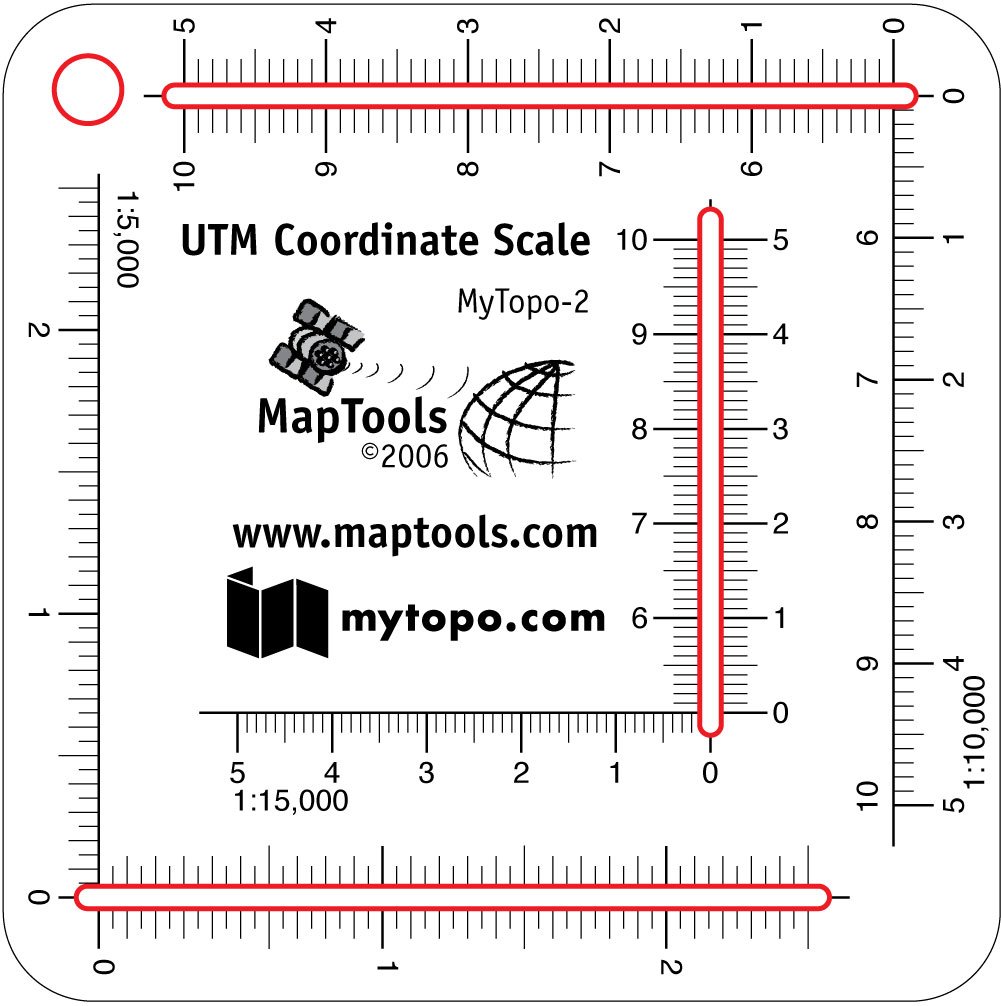
ItemName : Pocket Sized UTM Slots for My Topo Air Photos
ItemPackageDimensions_Height : 1 inches
ItemPackageDimensions_Length : 9 inches
ItemPackageDimensions_Width : 4 inches
ItemPackageQuantity : 1
ItemTypeKeyword : outdoor-recreation-topographic-maps
Language : english
Language1 : english
Language2 : english
Manufacturer : MapTools
MapScale : 1:63,360
MapType : Topographic
MapType1 : Topographic
MapType2 : Recreation
MapType3 : Travel
PaperFinish : matte
PaperSize : Letter
PartNumber : 223582
ProductDescription :
These pocket sized UTM tools are designed to be used with topographic maps and aerial photography printed by MyTopo's online map printing service. The tool includes the 3 scales used for aerial photography. Don't forget to turn on the UTM Grid option when you order your maps.
Scales: 1:5,000 x 50m 1:10,000 x 250m 1:15,000 x 500m
Approximate size is 2.75" by 2.75" (7cm X 7cm).
Internal cutouts are shown with a red outline in the product images. The map image in the background of some product images is present so that any white ink is visible. Neither the red outlines nor the map image are printed on the tool.
ProductSiteLaunchDate : 2011-07-28T23:59:59.000-08:00
PublicationDate : 2014-06-01T00:00:00.000-07:00
SubjectKeyword : 'area', 'denver', 'toll', 'mountain'
SupplierDeclaredDgHzRegulation : not_applicable
UnspscCode : 55101500