
Cart 2 india
In2Cart
Rs. 0
0


Product Information
Specification
Artist : Various Artists
Binding : apparel
Brand : Franko Maps
BulletPoint1 : NAVIGATE WITH EASE - This detailed map of the Channel Islands ensures you can explore confidently, whether diving or boating, with accurate locations and points of interest clearly marked.
BulletPoint2 : DURABLE AND RELIABLE - Crafted from waterproof, rip-resistant synthetic material, this map withstands harsh marine conditions, ensuring it remains intact and legible on every adventure.
BulletPoint3 : COMPACT AND PORTABLE - Measuring 4" x 7" when folded, this Channel Islands map easily fits in your pocket or dive bag, making it a convenient and essential travel companion.
BulletPoint4 : MAXIMIZE YOUR DIVING - Featuring a 13" x 19" unfolded size, this map provides comprehensive coverage of the Channel Islands, perfect for planning dives and understanding the local marine environment.
BulletPoint5 : TRUSTED CARTOGRAPHY - Rely on Franko Maps' expertise for accurate and up-to-date information, ensuring you have the best navigational tool for exploring the Channel Islands' waters.
ExternallyAssignedProductIdentifier1 : 819420000114
ExternallyAssignedProductIdentifier2 : 0819420000114
ExternallyAssignedProductIdentifier3 : 00018713531667
Format : cd_rom
GpsrSafetyAttestation : 1
ItemDisplayDimensions_Length : 6 inches
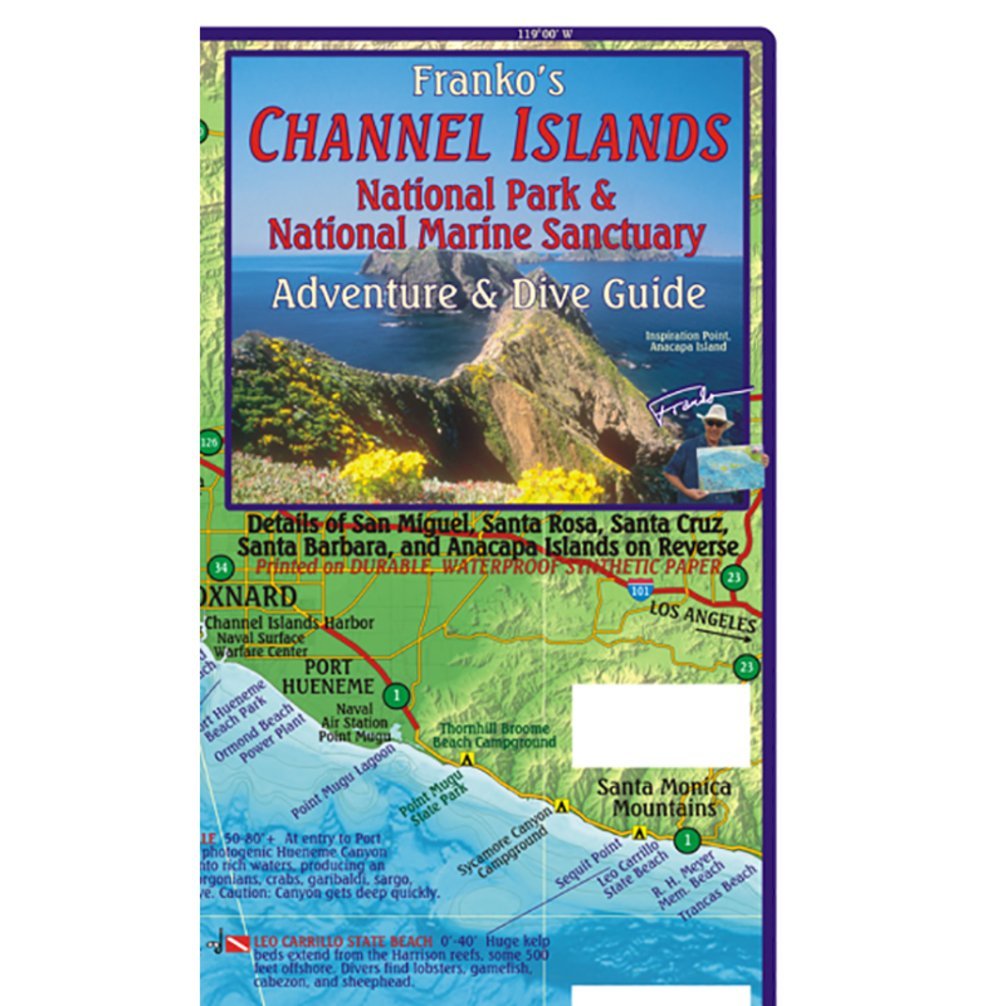
ItemName : Franko Maps Map FML Ca Channel Islands Guide & Dive
ItemPackageDimensions_Height : 1 inches
ItemPackageDimensions_Length : 14 inches
ItemPackageDimensions_Width : 6 inches
ItemPackageQuantity : 1
ItemTypeKeyword : outdoor-recreation-topographic-maps
Language : english
Manufacturer : Franko Maps
MapType1 : Road
MapType2 : Topographic
MapType3 : Trail
NumberOfDiscs : 1
NumberOfItems : 1
OperatingSystem1 : Windows 3.1, Windows 95, Windows NT
OperatingSystem2 : PowerMac OS 8.5
PaperFinish : watercolor
PartNumber : B402
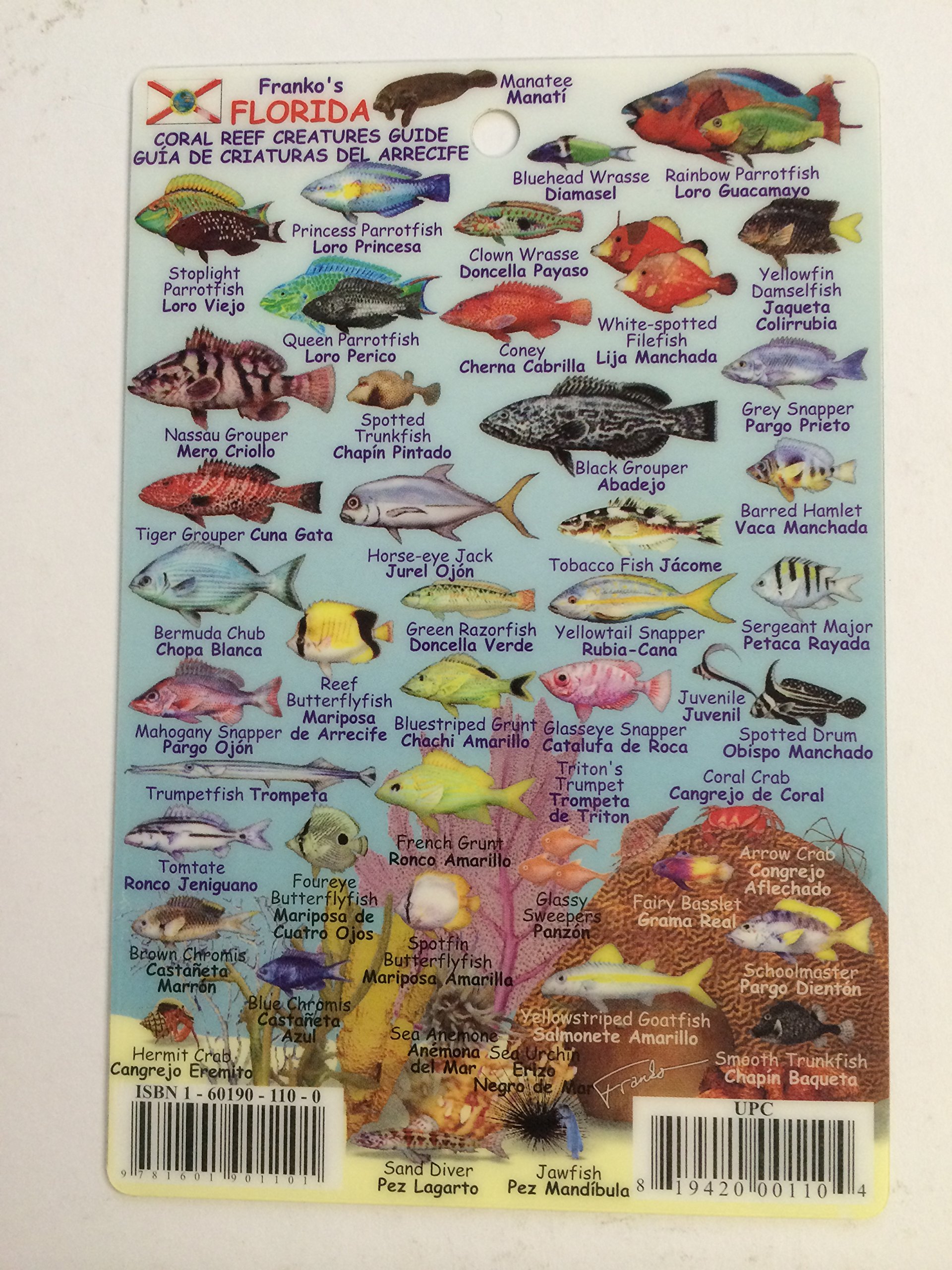
ProductDescription : Channel Islands:This colorful map gives you everything you need to know about the Channel Islands and the surrounding waters. This map is detailed with important facts about the islands and what you will find on land or under the water. Complete depth is depicted in descending hues of ocean blues to indicate actual ocean bathymetry and depth contours. Shaded relief accuracy is derived from USGS digital elevation models. Each dive spot is accurately described with what you will find when you dive the location, along with depth, recommended things to look for, and a detailed marine life guide. Side 1 of this map of the Channel Islands shows the Santa Barbara-Ventura Coast with the five islands (San Miguel Island, Santa Rosa Island, Santa Cruz Island, Anacapa Island, and Santa Barbara Island). Side 2 of the map shows each of the Channel Islands individually. The map is printed on waterproof, rip-resistant plastic, making it perfect to take along on your dive. If you are planning a trip to the California Channel Islands this map is a must. The map measures 13" x 19" (33cm x 48.25cm) and folds to a handy 4" x 7" (10.2cm x 17.8cm).
ProductSiteLaunchDate : 2013-06-20T14:29:40Z
SupplierDeclaredDgHzRegulation : not_applicable
UnspscCode : 55101500