
Cart 2 india
In2Cart
Rs. 0
0


Product Information
Specification
Binding : sports
Brand : Waterproof Charts
BulletPoint : Official FAA chart.
BulletPoint1 : Two Sided
BulletPoint2 : Foldable
BulletPoint3 : Tear Resistant Synthetic Paper (Hop-Syn) 5 PP Tree Friendly
BulletPoint4 : Split ring and hook for clipping to waders or boat
Color : blue ocean
ExternallyAssignedProductIdentifier1 : 740399002765
ExternallyAssignedProductIdentifier2 : 0740399002765
ExternallyAssignedProductIdentifier3 : 00794492402533
ImportDesignation : Made in USA
IncludedComponents : fishing-charts-and-maps
ItemDisplayDimensions_Length : 6 inches
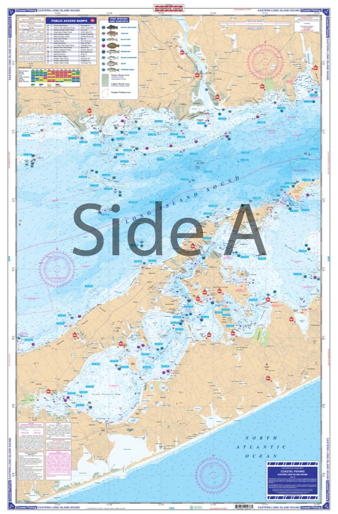
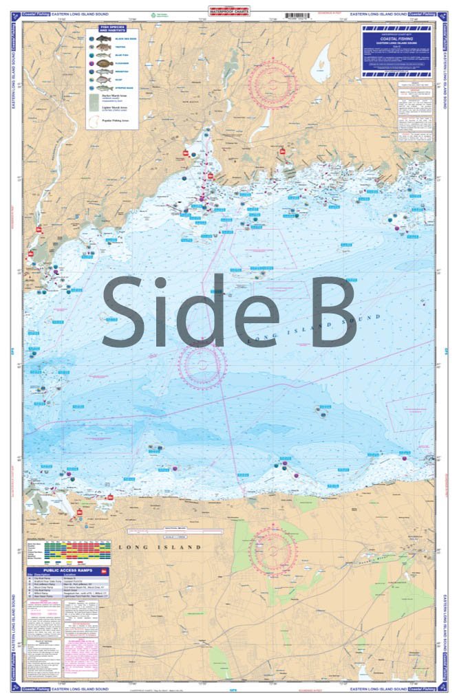
ItemName : Waterproof Charts, Coastal Fishing, 27F Eastern Long Island Sound
ItemPackageDimensions_Height : 32.5 centimeters
ItemPackageDimensions_Length : 0.2 centimeters
ItemPackageDimensions_Width : 16.8 centimeters
ItemPackageQuantity : 1
ItemShape : Rectangle
ItemTypeKeyword : fishing-charts-and-maps
Language : english
Manufacturer : Waterproof Charts
MapType : Navigational
MapType1 : Road
MapType2 : Topographic
MapType3 : Trail
Material : Polypropylene
ModelName : 123F
ModelNumber : 27F
NumberOfItems : 1
PaperFinish : smooth
PaperSize : 25 x 38 inches
PartNumber : 27F
ProductDescription : Coastal Fishing Chart. Side A has complete coverage from the Niantic River back to the Madison Reef on the Connecticut side and coverage from Plum Island into Gardiners Bay, Shelter Island, and Peconic Bays on the New York Side. Side B has coverage from Guilford Point down to Stratford Point on the Connecticut side and goes from Centerville down to Port Jefferson on the New York Side. This info comes from NOAA Chart #12354. Like all of the very popular Coastal Series from Waterproof Charts, we have enlisted the help of local fishing guides and tackle shops to pinpoint all of the fishing hot spots. These areas have been designated on the chart with the symbol of the species caught in that area along with the GPS coordinate.These designated areas will be the most likely spots to catch certain species for a given area. The local public access boat ramps have been listed as well. These charts come with dozens of pre-plotted GPS Waypoints and are a must have for the successful angler in pursuit of Striped Bass, Black Sea Bass, Bluefish, Flounder etc.,. Chart is 25" X 38". WGS84 - World Mercator Datum.
ProductSiteLaunchDate : 2013-03-29T01:37:13.775Z
SubjectKeyword : 'sport', 'non-fiction', 'fishing'
SupplierDeclaredDgHzRegulation : not_applicable
UnspscCode : 60101700