
Cart 2 india
In2Cart
Rs. 0
0


Product Information
Specification
Binding : miscellaneous
Brand : Waterproof Charts
BulletPoint : Laminated Fishing Chart
BulletPoint1 : Two Sided
BulletPoint2 : Foldable
BulletPoint3 : Tear Resistant Synthetic Paper (Hop-Syn) 5 PP Tree Friendly
BulletPoint4 : Meets U. S. and international carriage requirements for commercial vessels
BulletPoint5 : U. S. Coast Guard approved
Color : waterproof lamintated
ExternallyAssignedProductIdentifier1 : 740399015666
ExternallyAssignedProductIdentifier2 : 0740399015666
ExternallyAssignedProductIdentifier3 : 00740399022169
Format : folded_map
ImportDesignation : Made in USA
IncludedComponents : fishing-charts-and-maps
ItemDisplayDimensions_Length : 41.1 inches
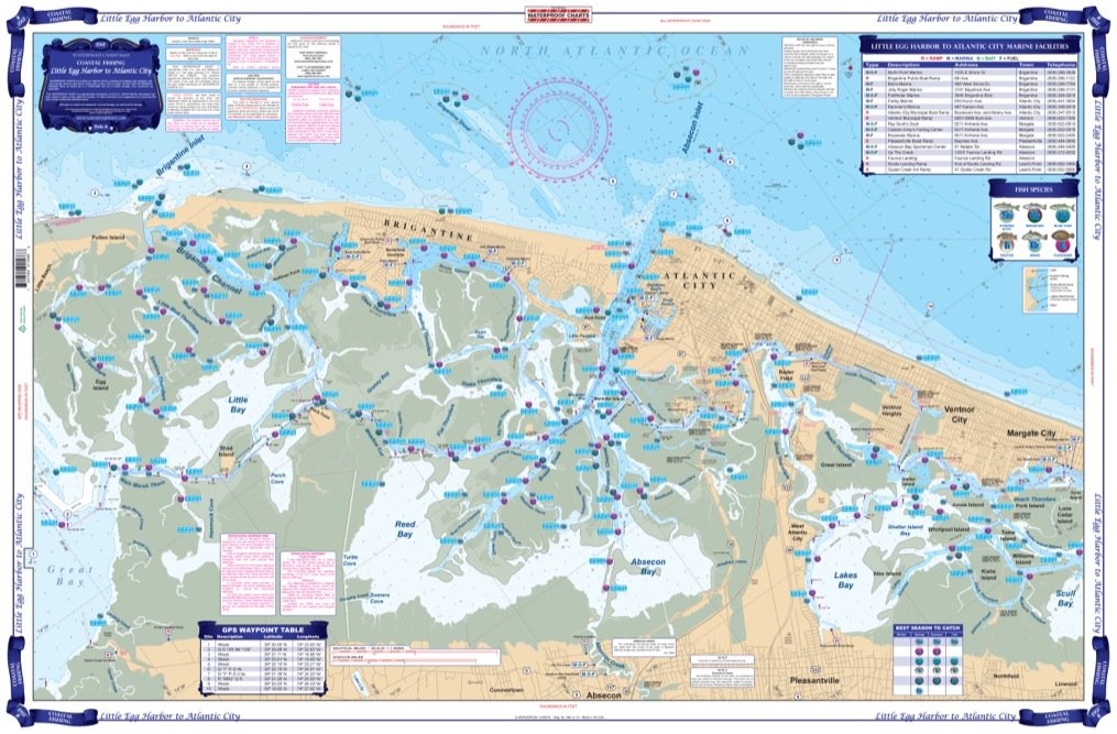
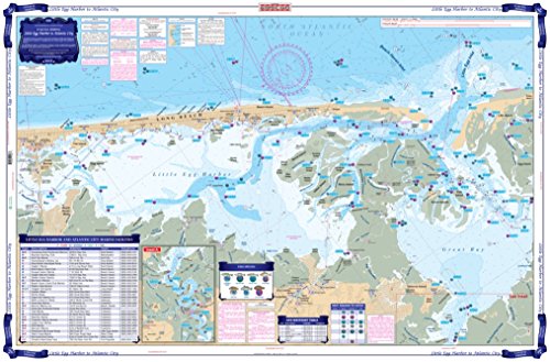
ItemName : Waterproof Charts, Coastal Fishing, 156F Little Egg Harbor to Atlantic City
ItemPackageDimensions_Height : 32 centimeters
ItemPackageDimensions_Length : 0.2 centimeters
ItemPackageDimensions_Width : 16.4 centimeters
ItemPackageQuantity : 1
ItemShape : Rectangle
ItemTypeKeyword : fishing-charts-and-maps
Language : english
Manufacturer : Waterproof Charts
MapScale : 1:24,000
MapType : Nautical
Material : Polypropylene
ModelName : 221F
ModelNumber : 156F
MountingType : Wall Mount
NumberOfItems : 1
NumberOfPieces : 1
Orientation : Landscape
PaintType : Watercolor
PaperFinish : premium_glossy
PaperSize : 19.5 x 26.5 inches
PartNumber : 156F
ProductDescription : Extremely detailed coverage including the complex inside waterways and rivers from the Route 72 bridge southwest to Little Egg Inlet and up the Mullica River. The reverse side continues from Great Bay and Brigantine Inlet to Atlantic City, Ventnor, and Margate City. This chart also covers Lakes Bay, Absecon Bay and Reed Bay as well as detail of Atlantic City and Absecon Inlet. GPS Coordinates. Information from NOAA Chart #12316. Chart is 25" X 38". WGS84 - World Mercator Datum.
ProductSiteLaunchDate : 2013-03-29T01:38:11.080Z
PublicationDate : 2017-08-19T00:00:00.000-07:00
ShipsGlobally : 1
Size : 19.5" x 26.5"
Style : Modern
SupplierDeclaredDgHzRegulation : not_applicable
TargetGender : unisex
TargetSpecies : Mackerel
Theme : Nature
UnitCount : 1
UnspscCode : 55101500