
Cart 2 india
In2Cart
Rs. 0
0


Product Information
Specification
Binding : apparel
Brand : NOAA
BulletPoint : Laminated Fishing Chart
BulletPoint1 : Printed on high quality water-resistant paper
BulletPoint2 : Always printed on demand using the most recent data from NOAA
BulletPoint3 : Prepared to be display quality. Arrives rolled, not folded.
BulletPoint4 : Detailed Scales: scale 1:50,000, with insets for added detail.
BulletPoint5 : Portable Size: Compact folded dimensions of 6" x 12" make it easy to carry and store.
Color : full color
ExternallyAssignedProductIdentifier1 : 0612524290265
ExternallyAssignedProductIdentifier2 : 612524290265
Format : unknown_format
ItemDisplayDimensions_Length : 40.8 inches
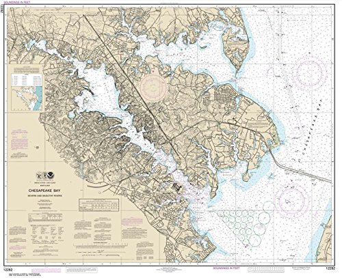
ItemName : NOAA Chart 12282: Chesapeake Bay Severn and Magothy Rivers, 33.2 X 40.8, Traditional Paper
ItemPackageDimensions_Height : 4 inches
ItemPackageDimensions_Length : 36 inches
ItemPackageDimensions_Width : 4 inches
ItemPackageQuantity : 1
ItemShape : Rectangular
ItemTypeKeyword : fishing-charts-and-maps
Language : english
Language1 : english
Language2 : english
Language3 : english
Language4 : english
Language5 : english
Manufacturer : Paradise Cay Publications
MapScale : scale 1:50,000
MapType : Nautical
MapType1 : Freshwater
MapType2 : Freshwater
MapType3 : Freshwater
MapType4 : Freshwater
MapType5 : Freshwater
ModelNumber : MT-13233
PaperFinish : glossy
PaperSize : 33.2 x 40.8 inches
PartNumber : NO_12282
ProductDescription : The MAPTECH Waterproof Chart WPC006-04, Peconic Bay to Montauk is an indispensable tool for navigating the waters around Montauk. This 4th edition chart provides highly detailed coverage of Peconic Bay making it a must-have for boaters and sailors exploring the region. The user-friendly, flip-fold format measures 24 inches x 36 inches when open and a compact 6 inches x 12 inches when folded, making it easy to store and reference on board. With scales of 1:53,333 and 1:57,140, and insets for added detail, this chart offers precise and comprehensive information. It features GPS waypoints for major buoys, courses and distances, wreck sites, and ramp locations and information, ensuring safe and efficient navigation. Printed on high-quality, waterproof synthetic paper, this chart is designed to withstand the elements, ensuring its longevity and reliability on the water. Whether you're an experienced mariner or a recreational boater, the MAPTECH Waterproog chart Peconic Bay is an essential tool for exploring the stunning coastal waters of Montauk.
ProductSiteLaunchDate : 2014-10-10T00:00:00.000-07:00
PublicationDate : 2019T
ShipsGlobally : 1
Size : 19.5" x 26.5"
Style : Traditional
SupplierDeclaredDgHzRegulation : not_applicable
SupplierDeclaredDgHzRegulation1 : not_applicable
SupplierDeclaredDgHzRegulation2 : not_applicable
SupplierDeclaredDgHzRegulation3 : not_applicable
SupplierDeclaredDgHzRegulation4 : not_applicable
SupplierDeclaredDgHzRegulation5 : not_applicable
UnspscCode : 55101500