
Cart 2 india
In2Cart
Rs. 0
0


Product Information
Specification
Binding : apparel
Brand : Captain Segull's Sportfishing Chart
BulletPoint : Laminated Fishing Chart
BulletPoint1 : Lake Namakagon is a real walleye producer in both size and numbers! Trophy muskie in the 50-inch range can also be had. Top-notch largemouth bass are overlooked.
BulletPoint2 : Made of durable, waterproof material
BulletPoint3 : Shaded depth areas
BulletPoint4 : Expertly researched, color coded, marked fishing areas included and boat accesses clearly marked
BulletPoint5 : Bend’Em, Fold’Em, Wipe’Em Clean
Color : waterproof laminated
ExternallyAssignedProductIdentifier1 : 0653210101052
ExternallyAssignedProductIdentifier2 : 653210101052
ExternallyAssignedProductIdentifier3 : 00738875000305
Format : folded_map
GpsrSafetyAttestation : 1
ImportDesignation : Made in the USA
ItemDisplayWeight : 1 pounds
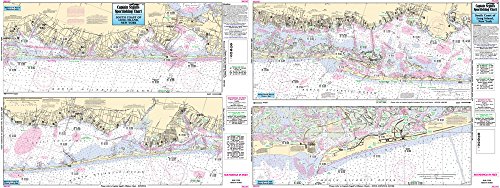
ItemName : Inshore South Coast of Long Island, NY - Laminated Nautical Navigation & Fishing Chart by Captain Segull's Nautical Sportfishing Charts | Chart # SLI107
ItemPackageDimensions_Height : 0.254 centimeters
ItemPackageDimensions_Length : 25.4 centimeters
ItemPackageDimensions_Width : 20.32 centimeters
ItemPackageQuantity : 1
ItemTypeKeyword : fishing-charts-and-maps
Language : english
Manufacturer : Captain Segull's Nautical Charts, Inc
MapScale : 1:24,000
MapType1 : Recreation
MapType2 : Topographic
Material : Plastic
ModelNumber : TM#1
NumberOfItems : 1
NumberOfPieces : 10
PaperFinish : glossy
PaperSize : 11x17 inches
PartNumber : SLI107
ProductDescription : Inshore Fishing Chart: An inshore chart 1-2 miles off the coast detailing the bays. South Coast of LI from Shinnecock Canal to Jones Beach Double sided laminated fishing Chart. Shows fishing areas, wrecks, reefs, local names and amenities in GPS out to the thousandths of a minute. 19.5" x 26.5"
ProductSiteLaunchDate : 2016-02-27T21:48:59.223Z
PublicationDate : 2017-12-17T00:00:00.000-08:00
Size : 19.5" x 26.5"
SupplierDeclaredDgHzRegulation : not_applicable
TargetSpecies1 : Trout
TargetSpecies2 : Salmon
UnitCount : 10
UnspscCode : 60101700