
Cart 2 india
In2Cart
Rs. 0
0


Product Information
Specification
Binding : apparel
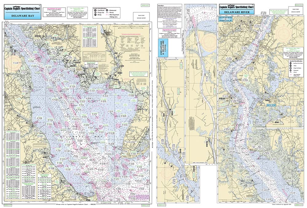
Brand : Captain Segull's Sportfishing Chart
BulletPoint : Laminated Fishing Chart
BulletPoint1 : 1 of a 2 Map Set. This Lake Eufaula is in OklahomaWhite bass are extremely abundant and popular with anglers. Fish in the 1- to 1 1/2-pound range are common. Although it is not known as a trophy bass lake, Lake Eufaula has good numbers of fish. It is primarily known as a crappie lake, and if you are looking for the big ones head south to the Gaines Creek area.
BulletPoint2 : Made of durable, waterproof material
BulletPoint3 : Shaded depth areas
BulletPoint4 : Expertly researched, color coded, marked fishing areas included and boat accesses clearly marked
Color : double sided
ExternallyAssignedProductIdentifier1 : 653210102707
ExternallyAssignedProductIdentifier2 : 0653210102707
ItemDisplayDimensions_Length : 41.1 inches
ItemDisplayDimensions_Width : 29.5 inches
ItemDisplayWeight : 2 pounds
ItemName : Captain Segull's Nearshore Delaware Bay Nautical Chart
ItemPackageDimensions_Height : 28.3 centimeters
ItemPackageDimensions_Length : 0.9 centimeters
ItemPackageDimensions_Width : 21.3 centimeters
ItemPackageQuantity : 1
ItemTypeKeyword : fishing-charts-and-maps
Manufacturer : Captain Segull's Nautical Charts, Inc
MapType : Nautical
MapType1 : Topographic
MapType2 : Navigational
NumberOfItems : 1
PaperFinish : watercolor
PaperSize : 33.6 x 38.8 inches
PartNumber : CSNDEL117
Pattern : Solid
ProductDescription : Inshore Fishing Chart: An inshore chart 1-2 miles off the coast detailing the bays. Delaware Bay, Delaware River to Wilmington, DE C & D Canal. Double sided laminated fishing Chart. Shows fishing areas, wrecks, reefs, local names and amenities in GPS out to the thousandths of a minute. 19.5" x 26.5"
ProductSiteLaunchDate : 2018-11-20T08:00:00.000Z
Size : 19.5" x 26.5"
Style : Waterproof
SubjectKeyword : 'reference', 'non-fiction'
UnspscCode : 60101700