
Cart 2 india
In2Cart
Rs. 0
0


Product Information
Specification
Binding : miscellaneous
Brand : NOAA
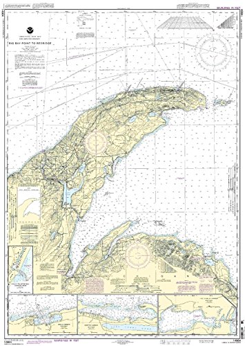
BulletPoint1 : Detailed coverage of Big Bay Point to Redridge;Grand Traverse Bay Harbor;Lac La Belle harbor;Copper and Eagle Harbors
BulletPoint2 : OceanGrafix provides mariners with the most up-to-date, NOAA-approved nautical charts ever offered
BulletPoint3 : Charts are printed only after an order has been received, ensuring the most up-to-date information
BulletPoint4 : Meets U. S. and international carriage requirements for commercial vessels, all notice to mariners corrections are applied.
BulletPoint5 : U. S. Coast Guard approved, Scale: 1:120,000, Size (inches): 34.31 X 48.83
ExternallyAssignedProductIdentifier1 : 0783847014842
ExternallyAssignedProductIdentifier2 : 783847014842
ItemDisplayDimensions_Length : 43.8 inches
ItemDisplayDimensions_Width : 26.5 inches
ItemDisplayWeight : 2 pounds
ItemName : 14964--Big Bay Point to Redridge by NOAA
ItemPackageDimensions_Height : 4 inches
ItemPackageDimensions_Length : 36 inches
ItemPackageDimensions_Width : 4 inches
ItemPackageQuantity : 1
ItemTypeKeyword : fishing-charts-and-maps
Manufacturer : NOAA
ModelNumber : MT-14964
NumberOfItems : 1
PaperFinish : watercolor
PartNumber : na
ProductDescription : Detailed coverage of Big Bay Point to Redridge;Grand Traverse Bay Harbor;Lac La Belle harbor;Copper and Eagle Harbors; OceanGrafix provides mariners with the most up-to-date, NOAA-approved nautical charts ever offered; Charts are printed only after an order has been received, ensuring the most up-to-date information; Meets U. S. and international carriage requirements for commercial vessels, all notice to mariners corrections are applied.; U. S. Coast Guard approved, Scale: 1:120,000, Size (inches): 34.31 X 48.83;
ProductSiteLaunchDate : 2006-08-13T20:03:35-00:00
ShipsGlobally : 1
Style : 1. Full-Sized Paper Chart - 26.5" x 43.8"
SupplierDeclaredDgHzRegulation : not_applicable
TargetAudience : Unisex Adults
UnitCount : 1
UnspscCode : 55101500